For nearly a century, they’ve sat there in silence—thousands of scooped-out pits clinging to a barren Peruvian hillside, marching in eerily neat rows along the edge of the Pisco Valley. Pilots noticed them first. Then archaeologists. Then, eventually, everyone else started asking the same question: why on earth would anyone dig more than 5,000 holes into a mountain?
Now, a team from the University of Sydney says the answer may be less mystical and far more human than previously imagined. Monte Sierpe—Spanish for “serpent mountain”—wasn’t a garden, a water trap, or a defensive structure. It may have been something much more practical: a massive, landscape-scale accounting system tied to ancient trade.
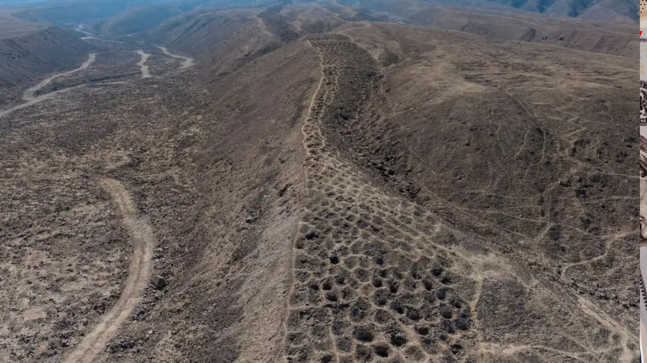
A mystery etched into the hillside

Monte Sierpe stretches nearly a mile (1.5 km) along a narrow ridge overlooking the Pisco Valley in southern Peru. From afar, the “Band of Holes” looks continuous, almost like a textured scar across the land. Up close, it’s more orderly—and stranger.
There are roughly 5,200 shallow pits, each about 1 to 2 meters wide and half a meter to a meter deep. They’re arranged in blocks, with deliberate gaps between sections that conveniently allow people to walk through. This wasn’t random digging. Someone planned this.
The site has puzzled researchers since 1933, when aerial photographs published by National Geographic first brought it to international attention. Over the decades, theories piled up: storage silos, military fortifications, agricultural terraces, even fog-catching devices for water collection. None of them fully fit the evidence.
Drones, data, and a numerical pattern

The breakthrough came when researchers, led by Dr. Jacob Bongers, used drones to map Monte Sierpe in unprecedented detail. From the air, patterns emerged that weren’t obvious on foot.
Rows of holes repeat the same numerical sequences. Some sections alternate between specific counts; others maintain long stretches of identical rows. It’s repetitive, structured, and frankly… mathematical.
That’s when the comparison clicked.

The layout bears a striking resemblance to an Inca khipu—a system of knotted cords used for accounting and record-keeping across the Andes. One such khipu was even recovered from the same valley. The difference? Instead of knots on strings, Monte Sierpe uses pits carved into earth and stone.
“This is an extraordinary discovery,” Bongers said, noting that it broadens what we know about Indigenous accounting systems in the Andes.
Not storage, but something smarter
Soil analysis inside the pits added another layer to the story. Researchers found ancient pollen from maize, squash, amaranth, cotton, chili peppers, and reeds traditionally used in basket-making. Here’s the catch: Monte Sierpe sits in an arid zone where these crops were never farmed.
Many of these plants also produce little airborne pollen, making natural deposition unlikely. In other words, people carried these goods to the site.
The leading theory now is that the holes functioned as markers of equivalence rather than storage silos. Goods may have been placed temporarily in baskets or bundles inside the pits, not buried or preserved long-term.
Seeing a row of filled holes could instantly communicate quantity—no written language, no currency required.
A prehistoric marketplace?
Radiocarbon dating places Monte Sierpe’s peak use in the 14th century, during the Late Intermediate Period (roughly 1000–1450 CE). At the time, the Chincha Kingdom dominated the region.
Historical accounts describe the Chincha as elite traders, operating vast networks along the coast and deep into the Andes long before the Inca arrived. According to chroniclers later cited by Spanish administrators, Chincha merchants used fleets of rafts and llama caravans to move goods between ecological zones.
Monte Sierpe sits right at a crossroads—between coast and highlands, near major pre-Hispanic road systems. That’s not an accident.
Bongers suggests the site may have functioned like a large open-air marketplace, where farmers, fisherfolk, and itinerant traders met to exchange goods. Corn for cotton. Fish for chilies. Quantities tracked visually, hole by hole.
You don’t need coins if everyone can see the math.
From Chincha trade to Inca administration
Things get even more interesting when the Inca enter the picture.
The Inca Empire was obsessed with accounting—tracking labor obligations, harvests, and state resources across an enormous territory. They relied heavily on khipus and visual systems rather than written text.
The segmented, numerical layout of Monte Sierpe would have been immediately legible to Inca administrators. Researchers believe the empire may have repurposed the site, using the existing infrastructure to manage labor or tribute.
It’s a reminder that empires don’t always build from scratch. Sometimes, they adapt what already works.
For background on Inca administrative systems, see the Peruvian Ministry of Culture’s overview of khipus (https://www.gob.pe/cultura) and UNESCO’s documentation on Andean record-keeping traditions (https://whc.unesco.org).
Why only here?
One of the biggest unanswered questions remains: if this system was so useful, why does it appear only at Monte Sierpe?
Bongers calls it a “landscape khipu,” a one-of-a-kind social technology born from specific regional needs. The Chincha’s trading dominance, population density—estimated at around 100,000 people—and geographic position may have made this kind of large-scale system both necessary and viable.
Comparable sites simply haven’t been found elsewhere in the Andes, despite extensive surveys documented by institutions like the Smithsonian National Museum of Asian, African and American Cultures (https://americanindian.si.edu).
Fact Check: Is this theory widely accepted?
The idea of Monte Sierpe as an accounting or trade system is still a hypothesis, not settled fact. However, it is supported by drone mapping, soil analysis, radiocarbon dating, and regional historical records. The findings align with what is known about Chincha trade networks and Inca administrative practices, as documented in peer-reviewed Andean archaeology journals and regional studies published through academic institutions like the University of Sydney and Peru’s Ministry of Culture.
No credible evidence currently supports claims that the site was used for alien signaling, astronomical calendars, or energy harvesting—popular myths that continue to circulate online.
A human story carved in dirt
At its core, Monte Sierpe isn’t about mystery for mystery’s sake. It’s about people solving practical problems—how to trade, how to measure, how to trust—without money, writing, or metal tools.
“These holes are a type of social technology,” Bongers argues. One that brought people together, facilitated exchange, and later helped an empire run its books.
After nearly a century of speculation, the Band of Holes is starting to look less like an enigma and more like a ledger—etched into a mountainside, waiting patiently for someone to read it properly.
FAQs:
Where is Monte Sierpe located?
Monte Sierpe is located in southern Peru, along the edge of the Pisco Valley near major pre-Hispanic road systems.
How many holes are at the site?
Researchers estimate there are approximately 5,200 pits arranged in structured rows and blocks.
Were the holes used for food storage?
Current evidence suggests they were not storage silos but markers used to represent quantities of goods.